Tulsa Forecast: Clouds today as warm weather holds across the area

A weak disturbance is moving across the state today, bringing some high and mid-level clouds to portions of the area. No measurable precipitation is expected for eastern Oklahoma, though a few sprinkles may reach the surface in isolated spots.
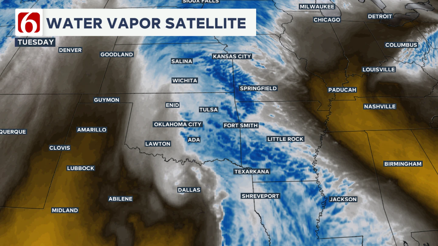
We can see that disturbance on the water vapor imagery.
How Warm Does It Get Today?
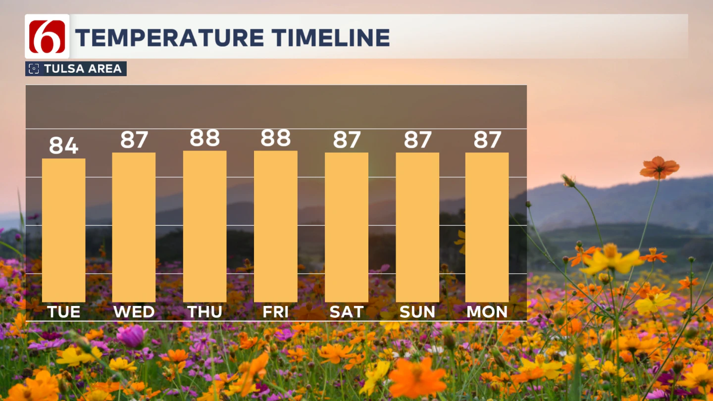
Temperatures will remain pleasant. Despite the cloud cover, afternoon highs are expected to reach the mid-80s.
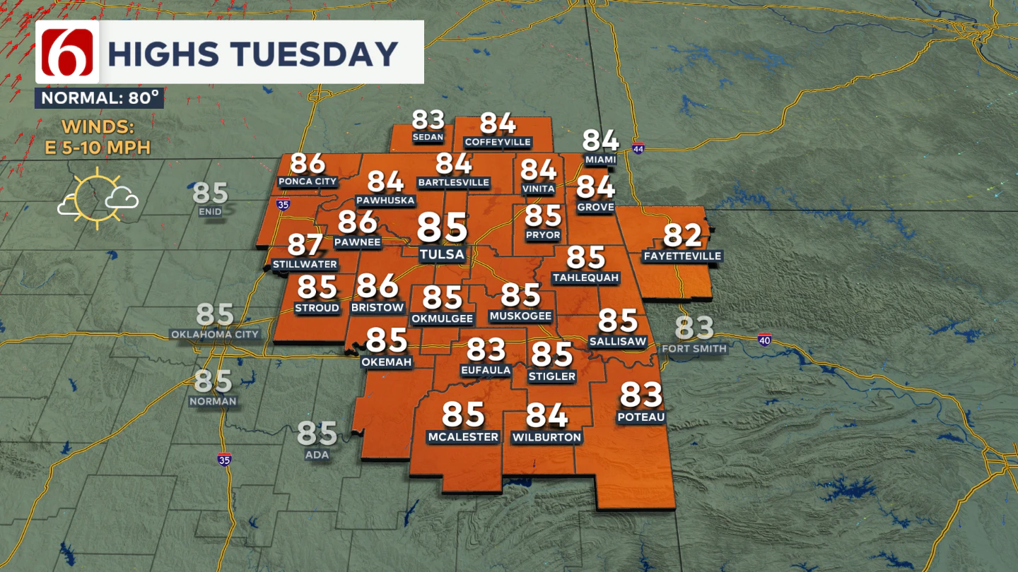
Winds will be light from the east to southeast, generally staying below 10 mph.
What About Wednesday?
As this wave exits the region late tonight into early Wednesday morning, patchy fog will be possible, mainly along and east of the immediate Tulsa metro.
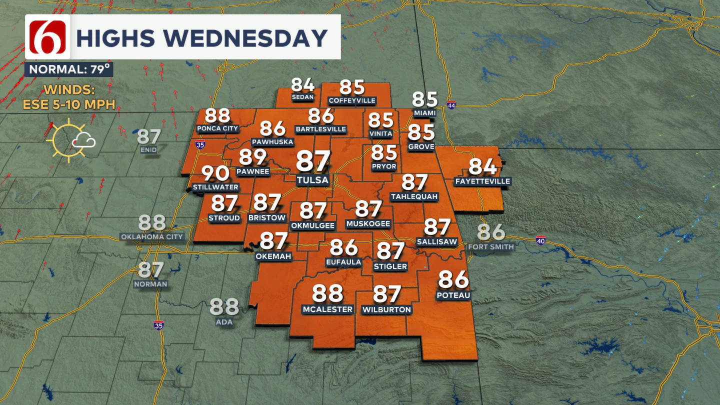
By 9 a.m., any fog should dissipate, leaving behind mostly sunny skies and warm conditions across the area. Wednesday afternoon highs will again reach the mid-80s.
Is The Dry Warm Pattern Sticking Around?
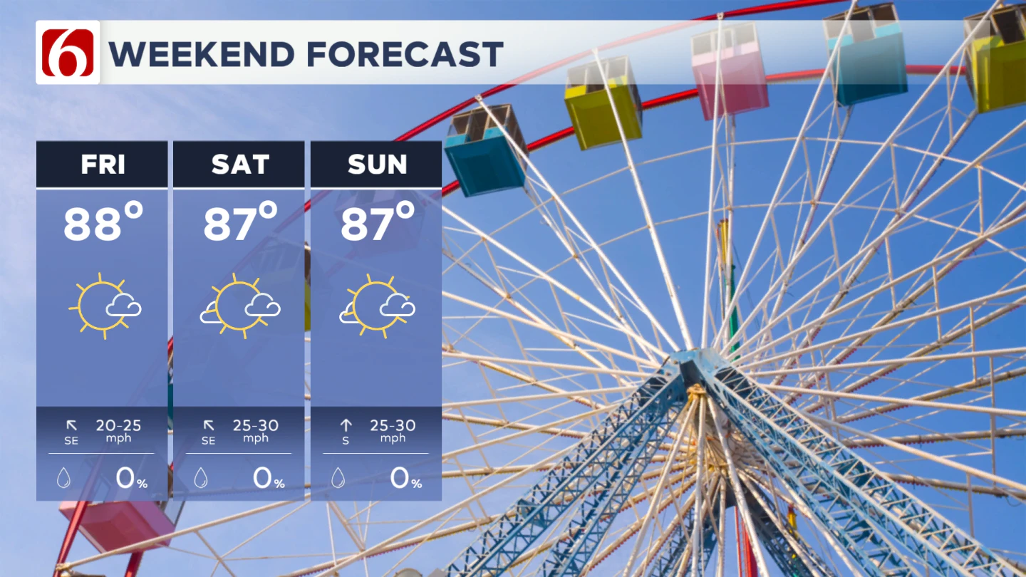
From Thursday through most of the weekend, expect morning lows in the lower 60s and afternoon highs in the mid to upper 80s.
By Friday, the upper-level pattern begins to shift as the mid-level ridge moves east, allowing a weak upper-level wave to move from the Rockies into the central Plains Saturday evening into early Sunday.
A surface low is expected to develop along the lee side of the Rockies and move into the central Plains Friday into Saturday. In response, southeast surface winds will increase to 15–25 mph from Friday through the weekend.
Any Rain This Weekend?
The southern edge of this wave may brush southern Kansas and extreme northern Oklahoma late Saturday night into early Sunday, potentially producing a few highly scattered storms.
The chance for measurable precipitation remains near or below 20% for southeastern Kansas and extreme northern Oklahoma, and less than 10% for the Tulsa metro for this forecast update regarding late in the weekend.
What About Next Week?
As the upper-level wave exits Sunday, the ridge is expected to reestablish itself early next week before weakening again as a stronger trough and associated cold front approach the state. We'll continue to keep highs above normal for the next several days.
What’s the Friday Night Football forecast?
Games will kick off with temperatures in the upper 70s and wrap up in the lower 70s. A steady southeast breeze between 10 and 20 mph is likely.
College Football Weekend Lineup
Kent State at University of Oklahoma
Location: Norman, OK
Kickoff: Saturday at 3:00 PM CDT
Tailgate (11:00 AM): Mostly sunny with a light southeast breeze around 10 mph. Temperature near 76°F
Kickoff (3:00 PM): Sunny skies, southeast wind 10–15 mph. Temperature around 84°F
End of Game (6:00 PM): Clear skies, temperature dropping to 79°F with a light breeze
-
Oklahoma State at Arizona
Location: Tucson, AZ
Kickoff: Saturday at 2:00 PM MST
Tailgate (10:00 AM): Sunny and dry, light southwest wind. Temperature near 78°F
Kickoff (2:00 PM): Sunny and breezy, southwest winds up to 13 mph. Temperature around 94°F
End of Game (5:00 PM): Clear skies, temperature easing to 88°F, winds calming slightly
-
University of Tulsa at Memphis
Location: Memphis, TN
Kickoff: Saturday at 7:00 PM CDT
Tailgate (3:00 PM): Mostly sunny with a light north breeze. Temperature near 83°F
Kickoff (7:00 PM): Clear skies, temperature around 76°F, winds light from the northeast
End of Game (10:00 PM): Clear and calm, temperature dipping to 70°F
The Illinois River Near Tahlequah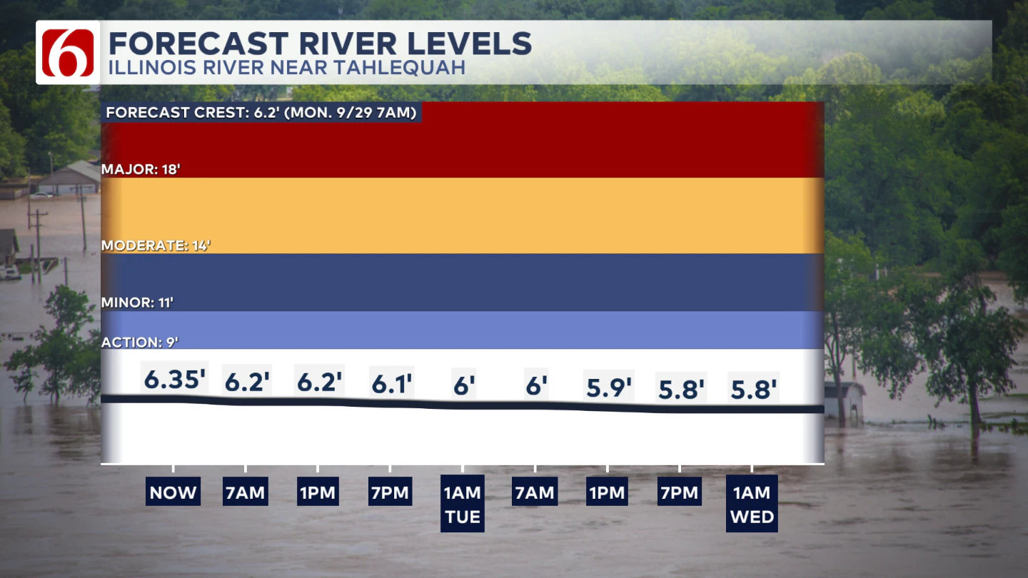
The Morning Weather Podcast:
The daily morning weather podcast briefing will remain on hold indefinitely due to ongoing internal workflow issues.
We're working to resolve these challenges as soon as possible and appreciate your patience. We apologize for the inconvenience and hope to be back soon. Thank you for your understanding.
Need-to-know severe Oklahoma weather prep:
🔗Severe weather safety: what you need to know to prepare
🔗Tornado Watch vs. Tornado Warning: what they mean and what to do
🔗Severe weather safety: what to do before, during, and after a storm
🔗Why registering your storm shelter in Oklahoma could save your life
🔗Floodwater kills more Oklahomans than tornadoes in the last decade, here's why
🔗'Turn around, don't drown': Flood safety tips for Oklahomans
🔗5 things to know: How Oklahomans can get federal money to install storm shelters
🔗Breaking down the SoonerSafe Rebate Program: Do I qualify for a storm shelter?
Watch us on YouTube
Follow NewsOn6 on X/Twitter for automated severe weather alert posts: @NewsOn6
Emergency Info: Outages Across Oklahoma:
Northeast Oklahoma has various power companies and electric cooperatives, many of which have overlapping areas of coverage. Below is a link to various outage maps.
- PSO Outage Map
- OG&E Outage Map
- VVEC Outage Map
- Indian Electric Cooperative (IEC) Outage Map
- Oklahoma Association of Electric Cooperatives Outage Map — (Note: Several Smaller Co-ops Included)