Nearing record highs soon before weekend storm chances return

A warming trend will continue over the next few days, with some locations nearing record highs by Wednesday ahead of a weak front crossing the area early Thursday morning.
The air mass behind the front will bring only minor changes. The overall pattern is expected to become more active soon, with chances for showers and storms increasing this weekend into early next week.
Severe threats are likely to return with these storms.
Warming Up Today and Wednesday
A mid-level ridge of high pressure will bring warm weather today and tomorrow before slowly shifting away later in the week.
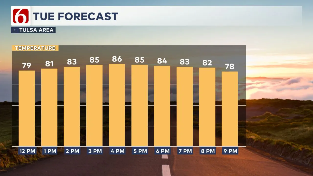
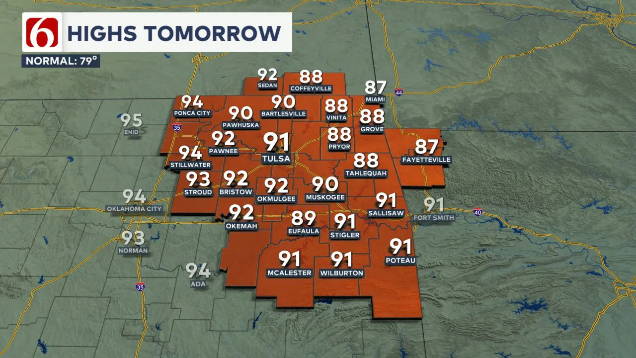
Early morning temperatures are in the upper 50s to lower 60s and will rise to the mid-80s this afternoon under mostly sunny skies.  South winds at 10 to 22 mph will return. The peak of the warming trend will come Wednesday afternoon, with morning lows in the mid to upper 60s and daytime highs reaching the lower 90s. The forecast for the Tulsa metro is for a high of 91°.
  The daily record high for May 14 is 93°, set in 1911. South winds at 10 to 22 mph will bring increasing low-level moisture, pushing heat index values into the lower to mid-90s.
Weak Front Arrives Early Thursday
A weak cold front will move across the area late Wednesday night into early Thursday morning, but a layer of warm air aloft (the cap) will likely prevent thunderstorms from developing.
As this front moves through, a strong upper-level system will rotate from the central Plains into the upper Midwest, where severe storms will be more likely. The stronger forcing will remain well north of our area.
North winds will persist briefly Thursday afternoon before shifting back to the south Thursday night into early Friday.
Friday into the Weekend
By Friday, the weak front will either become diffuse or lift northward as a warm front. There remains some uncertainty regarding the exact outcome of this boundary heading into the weekend.
Regardless, thunderstorm chances appear low, mainly affecting extreme northeastern Oklahoma and southeastern Kansas Friday night into early Saturday morning.
Friday’s temperatures will start in the lower 60s, with daytime highs climbing into the upper 80s near 90°. The probability of storm activity currently remains near 20%. But if storms develop, they would be strong to severe.
Storm Chances Increasing into Early Next Week
This weekend, south winds will continue to bring increasing low-level moisture into the region. Morning lows will be in the 60s, with highs reaching the mid to upper 80s.
Strong southwest upper-air flow will introduce additional disturbances near the state, increasing the probability of thunderstorms.  At this point in the forecast cycle, storm chances remain relatively low for Saturday but will increase by Sunday. Any storms that form would have the potential to be strong and severe.
Early Next Week
A powerful upper-level system is likely to be near the southern plains early next week.
Based on the current pattern, increasing probabilities for storms are likely Sunday into both Monday and Tuesday before a front moves across the area on Wednesday.
Based on the pattern, severe threats will be increasing during this period. You’re encouraged to check back often for updates, as this pattern can produce all modes of severe weather.
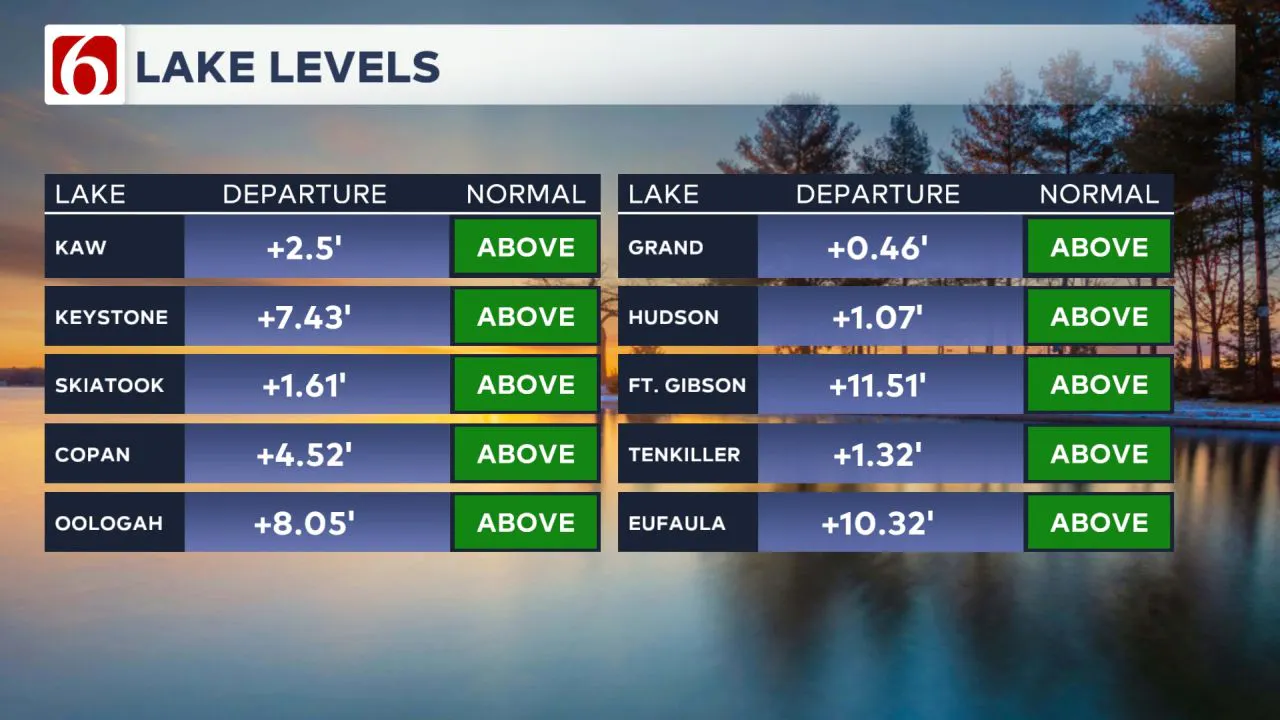
Lake Levels
Here's a quick look at some area lake levels as of Tuesday morning. 
The Morning Weather Podcast:
The daily morning weather podcast briefing will remain on hold indefinitely due to ongoing internal workflow issues.
We're working to resolve these challenges as soon as possible and appreciate your patience. We apologize for the inconvenience and hope to be back soon. Thank you for your understanding.
-----
Need-to-know severe Oklahoma weather prep:
🔗Severe weather safety: what you need to know to prepare
🔗Tornado Watch vs. Tornado Warning: what they mean and what to do
🔗Severe weather safety: what to do before, during, and after a storm
🔗Why registering your storm shelter in Oklahoma could save your life
🔗Floodwater kills more Oklahomans than tornadoes in the last decade, here's why
🔗'Turn around, don't drown': Flood safety tips for Oklahomans
🔗5 things to know: How Oklahomans can get federal money to install storm shelters
🔗Breaking down the SoonerSafe Rebate Program: Do I qualify for a storm shelter?
Watch us on YouTube!
Follow NewsOn6 on X/Twitter for automated severe weather alert posts >>>>>> @NewsOn6

Emergency Info: Outages Across Oklahoma:
Northeast Oklahoma has various power companies and electric cooperatives, many of which have overlapping areas of coverage. Below is a link to various outage maps.
- PSO Outage Map
- OG&E Outage Map
- VVEC Outage Map
- Indian Electric Cooperative (IEC) Outage Map
- Oklahoma Association of Electric Cooperatives Outage Map — (Note: Several Smaller Co-ops Included)
Follow the News On 6 Meteorologists on Facebook!