Wet Weather Returns Soon
If you’re into podcasts or in a rush, check out my daily weather update. Search for NewsOn6 and ‘Weather Out The Door’ on most podcast providers, including Spotify, Stitcher and Tune-In, or Click Here to listen on Apple Podcasts.
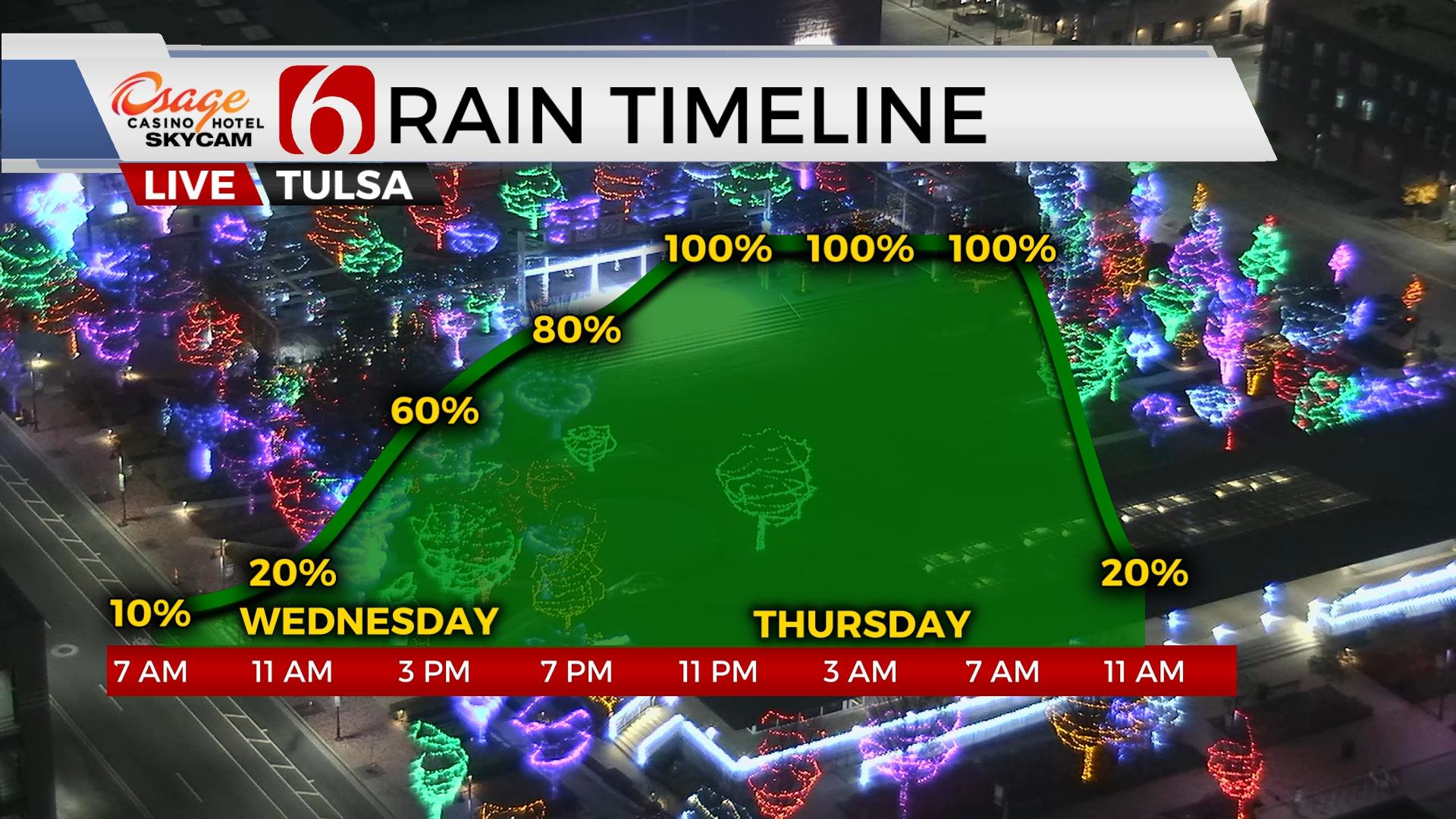
TULSA, Okla. - Grab the umbrella, shower chances return to Green Country on Wednesday.
Here are the details from News On 6 Meteorologist Alan Crone:

Rain returns on Wednesday and exits early Thursday morning. Another system quickly impacts part of the weekend before a powerful upper-level trough arrives early next week. Highs on wednesday will remain cool with many locations in the 50s. and exits early Thursday morning. Another system quickly impacts part of the weekend before a powerful upper-level trough arrives early next week. Highs on wednesday will remain cool with many locations in the 50s.

The front that moved across northern Oklahoma Tuesday morning is positioned across the south. A disturbance in the southwest flow has already triggered near the boundary on wednesday morning. The front will slowly lift northward, and additional rainfall is likely this afternoon and tonight before exiting the area Thursday morning. Locations near and north of I-40 and slightly south of highway 412 may see some locally moderate to heavy rainfall with this system. Precipitation amounts between one to two inches seem possible with a few localized areas of near three inches possible. A mostly dry soil and ground layer will handle most of the event with no significant flooding issues. Local streams and rivers may see an increase in flow and levels during the next few days. A few low-lying streets or crossings may have some minor flooding issues. No flood watch is posted at this time. After rain ends on Thursday morning, afternoon highs will range from the upper 60s west to upper 50s east. Some partial clearing occurs tomorrow afternoon near and west of the Tulsa metro with southwest winds near 10 to 20 mph. A surface front effectively moves back across the area Friday with north winds and morning lows in the 30s. Daytime highs will stay in the lower 50s Friday near the metro with slightly higher temps south and cooler north.

The next upper wave brushes the Red River Valley Friday evening into early Saturday morning with some scattered showers or thunderstorms. Severe weather is not expected. The timing of this system may keep most of the impact late Friday evening and exiting early Saturday morning. Most of the weekend appears in good shape other than the fast-moving system. A much stronger upper trough nears early next week and will provide strong to severe thunderstorm threats for the eastern third of the state.

Model depiction supports a strong trough nearing early next week. The positioning would bring powerful dynamics across the state either Monday or Tuesday. Low level moisture is likely to stream from the Gulf northward before the trough arrives. While still very early in the forecast cycle, a mention of strong to severe storms is warranted based on the pattern. Specific parameters, not known for a few days, may result in some changes regarding the timeline for thunderstorms. As the system passes, much colder air will arrive and remain for next week.
Thanks for reading the Wednesday morning weather discussion and blog.
Have a super great day!
Alan Crone
KOTV